
In Gainesville and Brentsville, groups of neighboring properties have been bundled (“assembled”) and offered for large-scale development. The Coalition tracks these because assemblages next to the former Digital Gateway campus follow the same pattern. This page collects what the public sources say about three areas: Sanders Lane (Dulles Cloud South), General Trimbles Lane (“Manassas Preserve”) and Catharpin Valley Estates.
Coalition map: land assemblages, north area (June 2026)
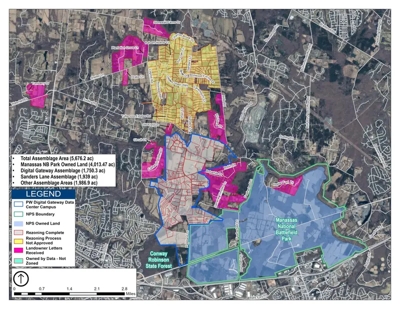
Source: Coalition map “Land Assemblages North” published with the June 27, 2026 post Dulles Cloud South: Digital Gateway “Part Deux” (original image on protectpwc.org). Click to enlarge. Colors: blue outline = Digital Gateway campus; yellow = rezoning process not approved; magenta = landowner letters received; red-outlined gray = rezoning complete; green outline = NPS boundary.
| Legend figure (as printed on the map) | Acres |
|---|---|
| Total assemblage area | 5,676.2 |
| Digital Gateway assemblage | 1,750.3 |
| Sanders Lane assemblage | 1,939 |
| Other assemblage areas | 1,986.9 |
| Manassas National Battlefield Park owned land (shown for context) | 4,013.47 |
The Digital Gateway entry reflects the former campus; QTS withdrew its Supreme Court petitions on July 2, 2026 (see Digital Gateway).
Assemblages and applications named in the sources
| Area | What the sources say | Source |
|---|---|---|
| General Trimbles Lane, “Manassas Preserve” CPA2026-00016, Gainesville District | About 255.81 acres in 12 parcels, along General Trimbles Lane roughly one mile south of the Featherbed Lane / Sudley Road (Rt 234) intersection, adjoining Manassas National Battlefield Park. Request: change the long-range land use from Agriculture & Forestry and Parks & Open Space to Residential Neighborhood (RN-3). County staff recommended that the Board not initiate the amendment. On the Board agenda July 21, 2026. | County staff report (PDF) |
| Catharpin Valley Estates CPA2026-00003, Gainesville District | About 292.79 acres in 30 properties, east of Catharpin Road, roughly 0.69 mile south of the Catharpin Road / Sudley Road intersection. Request: change from Agriculture & Forestry to Residential Neighborhood (RN-3); the requestor submitted a revised RN-2 request on June 11, 2026. The Board deferred initiation on May 12, 2026 (Res. 26-306) to July 21, 2026. County staff recommended not to initiate. | County staff report (PDF) |
| Combined (Coalition summary) | The Coalition describes the two Gainesville requests as assemblages totaling about 550 acres, removing hundreds of existing homes and replacing them with more than 3,500 housing units. The staff reports give 255.81 + 292.79 = 548.6 acres; the unit total is the Coalition’s figure and the staff reports show different unit counts by scenario. | July 14, 2026 alert; July 16 post |
| Sanders Lane / Dulles Cloud South Catharpin | Coalition posts describe a proposed data center corridor along Sanders Lane in Catharpin with a framework allowing up to 43 million sq ft of data center floor area (0.50 FAR), versus 22 million for Digital Gateway. The Board voted unanimously on July 7, 2026 against initiating the Dulles Cloud South amendment, per the Coalition’s July 12 post. The Sanders Lane assemblage covers about 1,939 acres, per the 2026 assemblage map. | June 27 post; July 12 post; 2023 document (DOCX) |
On July 21, 2026, the Board of County Supervisors voted to move both the General Trimbles and Catharpin Valley Estates assemblages forward; they are now going through the Comprehensive Plan Amendment (CPA) process.
(2) These two requests are residential land use amendments, not data center applications; they are included because the Coalition groups them with the assemblages beside the Digital Gateway. (4) The 2023 document contains private individuals’ contact details and prices, which are deliberately not reproduced here; consider whether to keep linking it.
Reference map (OpenStreetMap)
Markers show only named places from the sources: Sanders Lane, the Catharpin area, Featherbed Lane and Manassas National Battlefield Park. They are reference points, not property boundaries. Click a marker for details.
Base map © OpenStreetMap contributors. Marker positions are looked up from public OpenStreetMap place names, not from county parcel data. General Trimbles Lane and the exact Catharpin Valley Estates site were not found in OpenStreetMap, so Featherbed Lane and the Catharpin Road / Sudley Road area stand in for them.
Other maps checked
The Coalition’s Google My Map on protectpwc.org (Our Google Map) covers the 2014-2018 Haymarket transmission line routes only and has nothing on these assemblages, so it is not embedded here. The data center tracker and its data files do not list Sanders Lane, General Trimbles or Catharpin Valley Estates filings, as they track data center applications.