
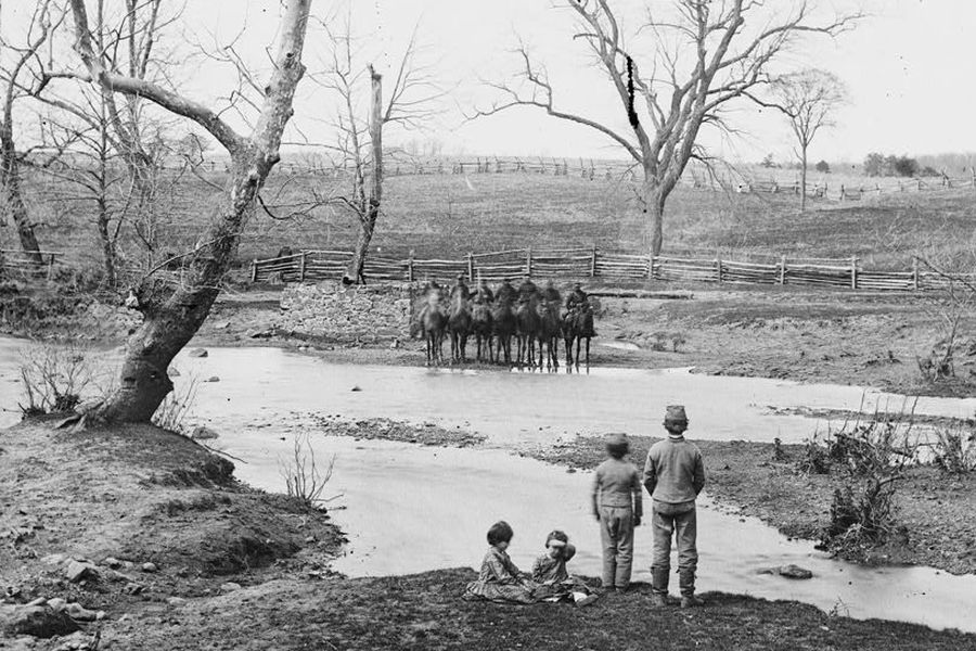
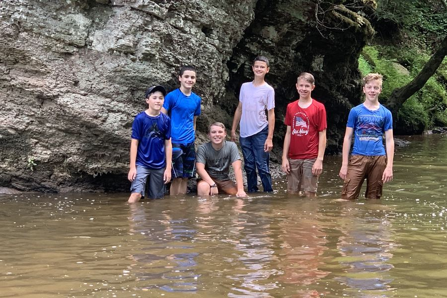
Generations on Bull Run: 1862 and 2019
The same waters children knew in 1862 are still a place to play today. What we preserve now is what the next generation inherits.
At the 1965 signing of the bill creating Assateague Island National Seashore, President Lyndon B. Johnson said:
“[I]f future generations are to remember us more with gratitude than with sorrow, we must achieve more than just the miracles of technology. We must also leave them a glimpse of the world as God really made it, not just as it looked when we got through with it.”
— President Lyndon B. Johnson, September 21, 1965
Questions on Water to Cool Haymarket Data Center
The accompanying data table depends on the PWCSA Capital Improvement Plan (2016-20).
From Martin Jensen –
Thank you for considering the pending resolution, which I believe makes reasonable accommodations for data centers in Prince William County. It’s remarkable that you are holding open public deliberation on this matter of such importance with significant implications for the future. In fact, this is in stark contrast to the secrecy around the roles of Amazon, Dominion Power, and the Prince William County Service Authority, the independent agency that provides clean water for so many of us.
I have five questions about meeting Amazon’s need for millions of gallons of water to cool data centers, including a new one planned across the street from the WalMart in Haymarket. I don’t expect you to answer these questions tonight. I offer them as something to think about.
1. How many people know that Amazon paid Prince William County Service Authority nearly $4.5 million last November to erase unpaid bills for water and sewer service at its existing data centers?
2. How many people know PWCSA records show that 273,000 gallons of water consumed by those data centers — and 300,000 gallons of waste water carried away and treated — between June and September 2014 — were subsidized for that period and to this very day by regular rate payers of the Service Authority’s customers?
3. How many people know that PWCSA did NOT refund or credit that $4.5 million to the accounts of its regular rate payers? That the funds were instead diverted to PWCSA accounts that pay for construction of service lines and for debt service on money borrowed to pay for construction? Money collected for water and for waste water removal was magically converted into construction funds!
Isn’t this diversion unfair to ordinary citizens of Prince William County — if not illegal — resulting in permanent excess charges against regular rate payers for water and sewer services — and in special treatment of a single corporate customer that needs huge water supplies & waste-water treatment for another data center at a place that’s not equipped to provide them?
4. How many people know a) That PWCSA adopted plans last year to spend over $16 million over 5 years for construction alone to provide new water mains and larger water supplies to the Haymarket area by 2019; b) that those plans included over $4.6 million for an enlarged line from a supply tower on Antioch Road, terminating at the site of the still-secret Amazon data center? c) that the total cost to increase just water service to the “Haymarket Pressure Zone” is today estimated at over $22 million through 2020 — up nearly $6 million in one year — under a new plan adopted last May without substantative public discussion by the PWCSA board of directors?
5. How many people don’t know these facts because of the official secrecy demanded by Amazon and because of Dominion Power withholding information on routing (and on when it will announce its favorite route for the high-voltage power lines), but also because of the culture of secrecy at PWCSA, dating back 30 years? No focused public oversight of PWCSA affairs by the government. No requirement to file reports with the State Corporation Commission, or to seek SCC approval of the rates PWCSA forces customers to pay, or of the policies underlying their shuffling of funds from one purpose to another without public notice or consent?
Birds and Bats!
Impacts on birds and bats by big powerlines
Virginia Department of Game and Inland Fisheries (A great resource for checking out the local birds and other wildlife within 3 miles of a location). The protected status of a species is shown in the Status column with these values:
FE=Federal Endangered; FT=Federal Threatened; SE=State Endangered; ST=State Threatened; FP=Federal Proposed; FC=Federal Candidate; FS=Federal Species of Concern; CC=Collection Concern
Sample output centered on Antioch Church (go to the site and enter your address to get a report for your area)
(displaying first 32) (32 species with Status* or Tier I** or Tier II** )
| BOVA Code | Status* | Tier** | Common Name | Scientific Name |
|---|---|---|---|---|
| 010032 | FESE | II | Sturgeon, Atlantic | Acipenser oxyrinchus |
| 060003 | FESE | II | Wedgemussel, dwarf | Alasmidonta heterodon |
| 060006 | SE | II | Floater, brook | Alasmidonta varicosa |
| 030062 | ST | I | Turtle, wood | Glyptemys insculpta |
| 040096 | ST | I | Falcon, peregrine | Falco peregrinus |
| 040129 | ST | I | Sandpiper, upland | Bartramia longicauda |
| 040293 | ST | I | Shrike, loggerhead | Lanius ludovicianus |
| 040379 | ST | I | Sparrow, Henslow’s | Ammodramus henslowii |
| 060081 | ST | II | Floater, green | Lasmigona subviridis |
| 040292 | ST | Shrike, migrant loggerhead | Lanius ludovicianus migrans | |
| 050022 | FP | Bat, northern long-eared | Myotis septentrionalis | |
| 010038 | FC | IV | Alewife | Alosa pseudoharengus |
| 010045 | FC | Herring, blueback | Alosa aestivalis | |
| 100248 | FS | I | Fritillary, regal | Speyeria idalia idalia |
| 040093 | FS | II | Eagle, bald | Haliaeetus leucocephalus |
| 100154 | FS | II | Butterfly, Persius duskywing | Erynnis persius persius |
| 100166 | FS | II | Skipper, Dotted | Hesperia attalus slossonae |
| 060029 | FS | III | Lance, yellow | Elliptio lanceolata |
| 030063 | CC | III | Turtle, spotted | Clemmys guttata |
| 030012 | CC | IV | Rattlesnake, timber | Crotalus horridus |
| 010077 | I | Shiner, bridle | Notropis bifrenatus | |
| 040372 | I | Crossbill, red | Loxia curvirostra | |
| 040225 | I | Sapsucker, yellow-bellied | Sphyrapicus varius | |
| 040319 | I | Warbler, black-throated green | Dendroica virens | |
| 040306 | I | Warbler, golden-winged | Vermivora chrysoptera | |
| 040052 | II | Duck, American black | Anas rubripes | |
| 040036 | II | Night-heron, yellow-crowned | Nyctanassa violacea violacea | |
| 040213 | II | Owl, northern saw-whet | Aegolius acadicus | |
| 040105 | II | Rail, king | Rallus elegans | |
| 040320 | II | Warbler, cerulean | Dendroica cerulea | |
| 040304 | II | Warbler, Swainson’s | Limnothlypis swainsonii | |
| 040266 | II | Wren, winter | Troglodytes troglodytes |
Resource Protection Area (RPA)
Taken from Prince William County Government: Resource Protection Area Requirements
Prince William County is located within the Chesapeake Bay Watershed. All of the creeks and streams in the County feed into the Potomac River and eventually the Chesapeake Bay. As part of its commitment to protecting the Bay, Prince William County adopted the Chesapeake Bay Preservation Act into its local ordinance in 1990. The Bay Act offers guidelines and requirements to protect and improve the water that flows into the Chesapeake Bay.
Vegetated areas along water bodies, such as lakes, streams, rivers, marshes or shoreline, are known as riparian buffers. Most of these buffers are included as Resource Protection Areas (RPAs) under the Bay Act. RPAs include the land area within 100 feet of a perennial stream bank or edge of wetlands adjacent to the perennial stream. RPA areas are protected under state law and local ordinances. In general, no development, land disturbance, or vegetation removal is allowed in an RPA. RPAs were designated along all perennial streams in the County. The County contacted all property owners with RPAs on their property to help them meet local requirements and play a role in protecting these important resources.
RPAs are described as the ‘last line of defense’ for the protection of water quality. These buffers stabilize shorelines and stream banks, filter pollutants, reduce volume of stormwater runoff and provide critical habitat for aquatic species and wildlife. Trees and shrubs in riparian buffers offer benefits to property owners as well by increasing property value, reducing erosion, reducing noise, improving air quality, increasing shoreline stability and providing shade in the summer and windbreaks in the winter.
Here are some RPA areas along the New Road Alternative Route


Related link: